Main Menu
Plan your Exciting Adventure
Planning your next Marietta adventure? Request a free copy of our visitor guide, packed with even more helpful details on where to dine, shop, stay and play across Marietta, Washington County and the surrounding region.
Request a guide
From historical attractions to outdoor excursions, there’s so much to see in Marietta and Washington County. Whether you want to center your visit around food and wine tasting, a special event, a scenic route, or just want to see a little of everything, we have you covered.
Weddings
Blennerhassett Island Historical State Park
wvstateparks.com/park/blennerhassett-island-historical-state-park
The Vault
Wedding Venue, VIP Conference center, Banquet Room
If there is a wedding in your future, you’ll find everything you need for your special day right here in Marietta and Washington County. The first step is finding the ideal location and we have an array of choices to suit any bride’s style. The area is home to many unique venues, from beautiful churches and elegant hotels to historic sites and rustic outdoor settings. Take some time to explore Washington County and you are sure to discover the perfect setting to begin your happily ever after.
Relocation
Washington County is a great place to live, work, play and stay. Ohio is located within a day’s drive of 50 percent of the U.S. population, making it an ideal location to start a business and bring your family. Within this close-knit, vibrant community, there are safe neighborhoods, and good schools. With diverse industries and job opportunities, affordable homes, and a low-cost of living, consider putting down roots in Marietta or surrounding communities.
For more information on Ohio industries and business opportunities including site selection in Washington County, please visit https://www.seohioport.com/sites-buildings/. For job information, please visit https://ohiomeansjobs.ohio.gov/.
Meetings & Conferences
The Vault
Wedding Venue, VIP Conference center, Banquet Room
Let our team at the Convention & Visitors Bureau help you with the heavy lifting when it comes to planning your next meeting in Marietta and Washington County, Ohio. You can rest assured our CVB can be trusted to make the recommendations we know will lead to a successful experience for planners. We know this city inside and out, including each hotel, venue and unique features that make “Ohio’s First Adventure” the perfect choice for your next gathering. Every convention involves dozens of moving parts. Transportation, parking, off-site venues, catering, and sleeping rooms are just a few things we are happy to help you with. We’re confident we can find the perfect venue to help elevate your next small to mid-sized meetings (up to 800 people).
Itineraries
Download one of our ready-made itineraries below, combine two or more, or design your own! Our office is standing by to make recommendations that can help you maximize your Marietta adventure.
MOTORCYCLE ROUTES
Whether you prefer to travel on two wheels or four, check out one of the various motorcycle tours that will provide you with a sense of freedom and adventure like no other. All rides begin at The Galley parking lot except for the Twisted Tour Route. The Galley is located at 203 Second St., on the corner of Second & Butler Streets in downtown
Marietta, Ohio.
Approximately 70 miles
Explore the western frontier of Washington County on an adventure crossing miles of scenic country highways. This route wanders with an exciting mix of tight twists, sweeping curves, and wide open stretches along pastures, fields of flowers, and through the woods.
Left on 2nd Street to Putnam Street
Left on Putnam Street, cross bridge
Left at light onto Gilman Ave (which becomes Virginia St)
Virginia Street becomes Rt. 550
Rt. 550 to Rt. 339
Left on Rt. 339 to Rt. 7
Right on Rt. 7 to Rt. 555
Rt. 555 to Rt. 676
Right on Rt. 676 to Marietta
Approximately 72 miles
Blaze a trail down a country road on the Crooked Tree Route and explore rural southeastern Ohio. You’ll wind through picturesque farms, time-forgotten towns, and towering woods on paved roads that scale some of the highest elevations in Washington County. Drivers should be alert to watch for deer any time of the year.
Butler Street to 3rd Street
Left on 3rd Street
3rd Street becomes Rt. 60
Turn right on Rt. 83
Right on Rt. 83 to Rt. 78
Right on Rt. 78 to Rt. 821
Rt. 821 to Rt. 60
Left on Rt. 60 back to Marietta
Approximately 133 miles
Snaking through eastern Washington County and into Wayne National Forest, the Twisted Tour Route covers miles of American wilds on challenging roads with exhilarating rewards. This shapely trek is full of road-hugging turns – eye candy that requires driver concentration.
Rt. 26 to Rt. 800
Right on Rt. 800
Left on Rt. 255
Left on Rt. 7
Left on Rt. 536
Left on Rt. 78
Left on Rt. 145
Left on Rt. 821 back to Marietta
Approximately 94 miles
From the river to the forest, journey along the Scenic Byways Route and discover miles of breathtaking views perfect for motorcycle or automobile expeditions. Cliff-side views and beautiful turns make this one of Life Magazine’s Top 40 Most Scenic Drives.
Right on 2nd Street to Greene Street
Left on Greene Street
Greene Street becomes Rt. 7
Left on Rt. 800 to Rt. 26
Left on Rt. 26 back to Marietta
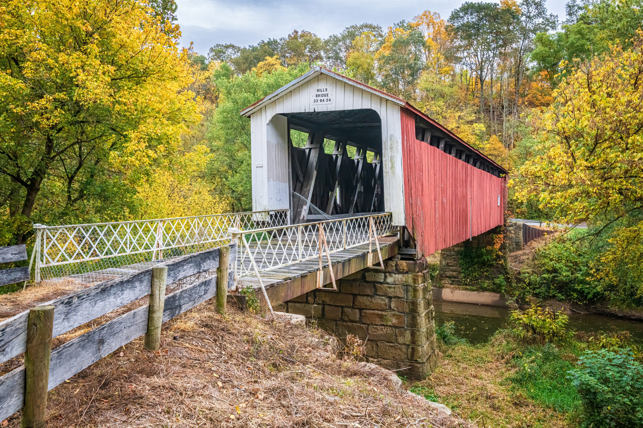
WASHINGTON COUNTY COVERED BRIDGE TOUR
There are two routes on the Washington County Covered Bridge Tour – the western loop and the eastern trail. Both paths take travelers through some of the most scenic and hilly terrain in southeast Ohio. The western loop veers off the pavement and onto some dirt roads, which are best covered during ideal weather conditions and/or with a four-wheeled drive vehicle. This path gives explores a view of the many family farms, tiny picturesque villages, ghost towns, country churches and cemeteries of the western portion of the county. The eastern trail consists exclusively of paved roads on a steep and curvy journey winding along the Wayne National Forest. The bridges on this path are well-marked and easy to find.
There are three well-marked covered bridges along State Route 26 north of Marietta. These three bridges border a portion of the Wayne National Forest
Follow State Route 26 and the Scenic Byway northeast of Marietta for about six miles to County Road 333 or Hills Bridge Road. Turn right on Hills Bridge Road and drive about a quarter of a mile to the Hills Covered Bridge.
Get back on SR 26 and continue northeast about 12 miles through Moss Run and Dart to Township Road 921 or Duff Road where the Hune Covered Bridge spans canoe access to the Wayne National Forest.
Continue on SR 26 for about 1.5 miles through Wingett Run to the Rinard Covered Bridge.
Return to Marietta on State Route 26 – a distance of about 22 miles
Six of Washington County’s nine public bridges are located along the Western Loop of the covered bridge tour.
Beginning in Marietta, take State Route 7 south to State Route 550. Drive west on 550 for about 12.5 miles to the intersection with State Route 339 where you will find the Barlow Fairgrounds –and the home of the Mill Branch Covered Bridge.
Departing the fairgrounds, drive north on State Route 339 for about half a mile to Township Road 39 or Bell Road. Continue on T39 for about 2.5 miles to the Bell Bridge.
Passing through the Bell Bridge, continue on T39 for 1.5 miles to Woodruff Road or T230. Turn right on Woodruff Road and travel east about 1 mile to State Route 339. Take SR 339 about three miles north, past Watertown, to Camp Hervida Road (T108). Drive about half a mile on Camp Hervida Road to the Harra Covered Bridge.
Backtrack half a mile on Camp Hervida Road to State Route 339. Turn right and drive south on SR 339 to State Route 676. Turn right on SR 676 and continue about eight miles to Township Road 91. Continue for about three miles on T91 to the Shinn Covered Bridge.
Continue along T91 for about two miles to County Road 206. Turn left and travel south on CR 206, or Patten Mills Road, about 3.5 miles to State Route 555. Continue south on SR 555 for about five miles to Township Road 61 or Clark Road. Turn left onto Clark Road and travel about one mile north to The Henry Covered Bridge
Backtrack on Clark Road to State Route 555. Turn left on SR 555 and drive about three miles to County Road 6. Turn left on C6 and travel about half a mile to the Root Covered Bridge.
Backtrack on County Road 6 to State Route 555. Turn left and continue traveling south on SR 555 to State Route 7/US 50. Follow SR 7 north back to Marietta – a distance of about 19 miles.
Planning your next Marietta adventure? Request a free copy of our visitor guide, packed with even more helpful details on where to dine, shop, stay and play across Marietta, Washington County and the surrounding region.
Request a guide